Cumulative rainfall totals up to 100 mm are possible across southeast NSW and parts of the ACT into Friday. Photo: Michelle Kroll.
T-shirts and shorts may have been the order of the day over the October long weekend, but don’t pack away your puffer jacket just yet.
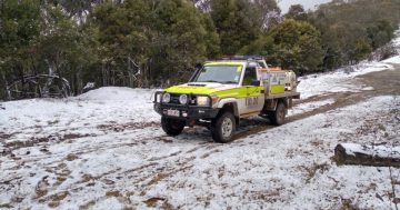
The weather across the ACT and southeast NSW is about to take a dramatic dive, as indicated already by wild winds in the Alpine areas.
A strong cold front has been making its way across the country, preceded by hot and gusty northerly winds that have elevated the fire danger across the region.
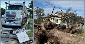
That’s what’s led to damaging winds and heavy rainfall warnings from the Bureau of Meteorology, with 135 km/h gusts already recorded at Thredbo and 114 km/h gusts in the Perisher Valley.
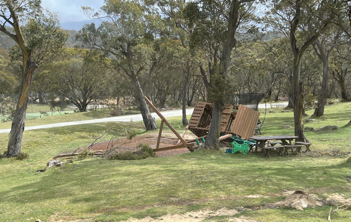
It’s not just trees that can be blown away by wild winds, as shown by this playground at Lake Crackenback. Photo: Supplied.
Strong winds have been felt more broadly across the Snowy Mountains, South Coast and southern ACT today (3 October), but they’re expected to contract back into the Alpine areas by the evening.
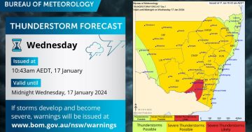
Senior meteorologist Sarah Scully explained Wednesday (4 October) was expected to be a “big day” with regards to severe weather in the region.
“That’s thanks to a low-pressure system that’s expected to rapidly intensify as it draws down tropical moisture from the north,” she said.
“We’re forecasting a broad area of rain extending from southern Queensland … into southeast NSW, including the Riverina.”
The low-pressure system brings the potential for severe thunderstorms, which could include damaging wind gusts.
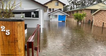
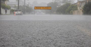
Six-hourly rainfall totals between 50 mm and 60 mm are possible in the Riverina area from this evening, leading to a flash flooding warning being issued for the area.
Over the next 24 hours, totals of 90 mm to 100 mm of rain are possible, with flood watches current for southeastern catchments.
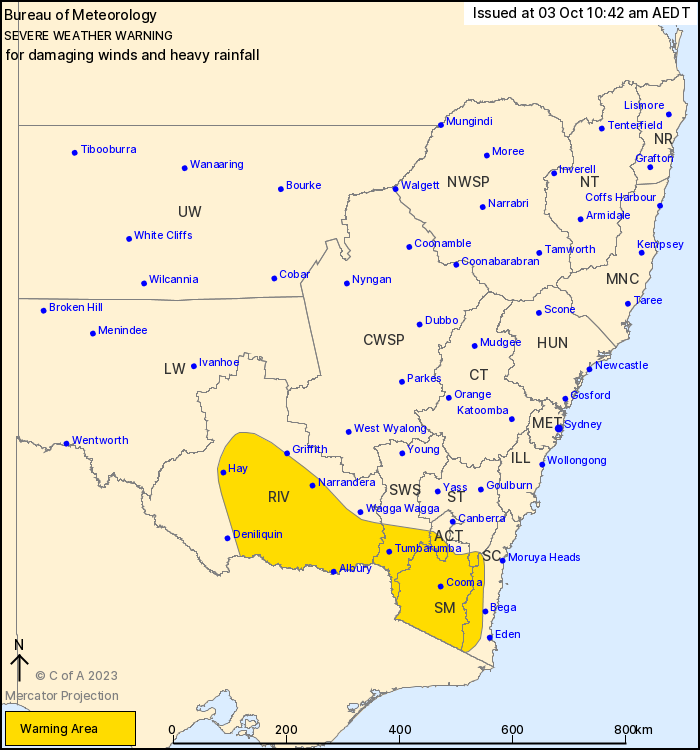
A severe weather warning for damaging winds and heavy rainfall has been issued for some parts of the ACT and southern NSW. Photo: BoM.
The system will continue pushing east into Thursday (5 October), with Ms Scully stating the damaging winds and heavy rainfall were expected to contract down around the NSW south coast and eastern Victoria.
This will direct heavy showers and gale-force south-westerly winds across the NSW South Coast and East Gippsland in Victoria.
“Then the low skirts off [into the ocean] and the weather starts to really improve by Friday,” Ms Scully said.
Cumulative rainfall totals in some parts of the southeast border of NSW and the south coast could be upwards of 100 mm by Friday.
Temperatures will be well below the October average, with the winds making things feel even colder.
It follows Australia recording its driest September since observations began in 1900.
According to the Bureau of Meteorology’s (BoM) climate statement for September, the country’s rainfall was 70.8 per cent below the 1961 – 1990 average for the month.
“The month was dominated by high-pressure systems which brought settled weather conditions and cloudless sky for most of the country,” it stated.
“For NSW as a whole, September was the second-driest on record, 82.6 per cent below average.”
September was also much warmer than the average for most of the country.
“With the exception of the Northern Territory, all other states were in the top ten warmest Septembers on record,” the BoM stated.
“[However] mean minimum temperatures were cooler than average for a large area of the southern NSW and for areas scattered across northern Australia.”
Some weather events tried to buck the warm and dry trend, such as when polar air blew across southeastern Australia at the start of the month, bringing showers, thunderstorms and even snow to some parts.
This was countered by unusually warm conditions that developed in mid-September.
“From the 17th until 20th, a low intensity-to-severe heat warning [was] issued for the South Coast district of NSW, along with Greater Sydney’s first Total Fire Ban since November 2020,” the BoM stated.
“Many [weather recording] stations had their highest daily maximum and minimum temperature for September on record. In addition, a number of stations, including … Canberra Airport, set September records for the number of consecutive days above threshold temperature.
“Hot and dry weather with strong northerly winds resulted in … a catastrophic fire danger warning for the NSW’s Far South Coast on the 19th.”
With more wild weather expected, the community has been advised to:
- Move vehicles under cover or away from trees.
- Secure or put away loose items around your house, yard and balcony.
- Keep at least 8 metres away from fallen power lines or objects that may be energised, such as fences.
- Report fallen power lines to either Ausgrid (131 388), Endeavour Energy (131 003), Essential Energy (132 080) or Evoenergy (131 093), as shown on your power bill.
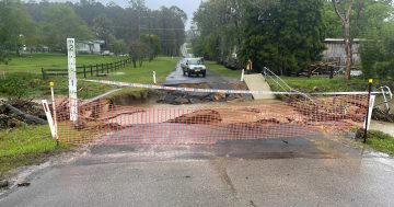
- Don’t drive, ride or walk through floodwater.
- Keep clear of creeks and storm drains.
- If you are trapped by flash flooding, seek refuge in the highest available place and ring 000 if you need rescue.
- Be aware that run-off from rainfall in fire-affected areas may behave differently and be more rapid. It may also contain debris such as ash, soil, trees and rocks.
- After bushfires, heavy rain and the loss of foliage can make the ground soft and heavy, leading to a greater chance of landslides.
- Stay vigilant and monitor conditions. Note that the landscape may have changed following bushfires.
For emergency help in floods and storms, ring your local SES Unit on 132 500.
The next severe weather warning is expected to be issued by the BoM by 5 pm.
Original Article published by Claire Fenwicke on Riotact.