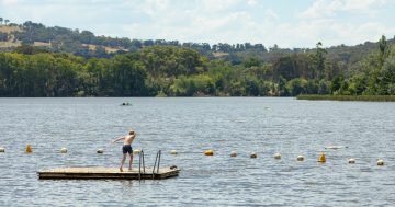
Remember to slip, slop, slap, seek and slide no matter where you are this October long weekend. Photo: Claire Fenwicke.
Whether you’re smelling the flowers at Floriade, taking a dip on the South Coast or mountain biking in the Snowies, everyone has been urged to keep their eye on the weather this October long weekend.
The weather system which broke heat records in Perth earlier in the week is making its way across the country and will hit southeast NSW and the ACT in the coming days.
Bureau of Meteorology meteorologist Dr Helen Reid explained a high-pressure system was making its way to the region, to be followed by a trough that will pull down warmer air from the north, which meant we’d be experiencing temperatures from 10 to 12 degrees above average for this time of year.
“We’re going to see a lot of warmth and heat building ahead of the trough … I’m not sure it will be record-breaking [like in Perth] but it will be unseasonably warm,” she said.
“We expect to see dry heat and no rainfall with it.”
Humidity hasn’t been building significantly on the South Coast either, and the winds ahead of the next trough will be dry as well.
This can increase the risk of dehydration and heat-related illness, as the dry air can whip away any sweat and leave you not realising you’re already losing moisture.
Due to this, Dr Reid advised everyone to keep an eye on the weather forecast no matter where you go this October long weekend.
“We could see even higher [temperatures] come through, the forecasts will continue to adjust,” she said.
“Be aware of forecasts and recognise how you’re feeling different when out in the elements.”
This dry heat has firefighters on alert as well.
Fire permits have already been suspended in the Far South Coast fire district (which includes the Bega Valley and Eurobodalla regions) until midnight on 5 October, while the statutory Bush Fire Danger Period will begin on Sunday, 1 October, for the Goulburn Mulwaree, Upper Lachlan Shire and Yass Valley local government areas.
NSW RFS Far South Coast coordinator Chris Anderson said they expected Sunday to be when there would be a “spike” in the heat.
“We’re expecting there could be an extreme fire rating that day, due to the higher temperatures in the mid-30s, low relative humidity and little wind … this could lead to a total fire ban on Sunday as well,” he said.
“[Other factors] driving that forecast include significant underlying dryness of grasslands … and there’s been a loss of soil moisture as we’ve had no significant rain for months now.”
Mr Anderson said fire permits had been banned in his jurisdiction was because there had been a few prescribed burns, which had been extinguished, re-igniting in the hot, drier and windy weather.
He urged anyone in the area to keep an eye on the Hazards Near Me app, which allows you to set a notification zone for wherever you are.
“We encourage people to stay up-to-date with the weather … especially leading into Sunday.”
The east coast will experience a brief cooler change on Sunday night and Monday before heating up again on Tuesday.
The risk of coastal drowning is generally doubled on public holidays and long weekends, with everyone who’s jumping in the surf urged to only do so at a patrolled location and to swim between the red and yellow flags.
Surf Life Saving NSW director of lifesaving Joel Wiseman encouraged potential beachgoers to understand their limitations when visiting the coastline.
“Too often we have seen tragic incidents where a person has drowned while trying to rescue someone else. You might be a good swimmer yourself, however trying to save someone else, often without any rescue equipment or training, is extremely difficult and dangerous,” he said.
“If you do see someone in trouble at an unpatrolled location, call for help, dial Triple-Zero and if you must attempt the rescue yourself, take a minute to try to locate some form of rescue device or flotation aid like a bodyboard to take with you.”
Here’s your October long weekend weather forecast for wherever you are in southeast NSW and the ACT:
Australian Capital Territory
Saturday 30 September: Sunny with light winds. Overnight temperatures falling to between 5 and 8 degrees, with daytime temperatures reaching 22 to 27 degrees.
Sunday 1 October: Sunny with variable winds increasing. Overnight temperatures falling to between 9 and 13 degrees, with daytime temperatures reaching 23 to 30 degrees.
Monday 2 October: Mostly sunny with light winds. Overnight temperatures falling to between 7 and 10 degrees, with daytime temperatures reaching 23 to 28 degrees.
Australian Alps – Snowy Mountains
Saturday 30 September: Sunny with a chance of frost in the north in the early morning.
Sunday 1 October: Mostly sunny with variable winds increasing.
Monday 2 October: Mostly sunny with the chance of morning frost near the Victorian border.
South Coast
Saturday 30 September: The chance of fog in the early morning before a sunny day with variable light winds. Overnight temperatures falling to between 7 and 11 degrees, with daytime temperatures reaching around 30 degrees.
Sunday 1 October: Mostly sunny with variable winds. Overnight temperatures falling to between 11 and 15 degrees, with daytime temperatures reaching 29 to 35 degrees.
Monday 2 October: Partly cloudy with winds dropping. Overnight temperatures falling to between 7 and 12 degrees, with daytime temperatures reaching 22 to 27 degrees.
Southern Tablelands
Saturday 30 September: Sunny with light variable winds. Overnight temperatures falling to between 4 and 7 degrees, with daytime temperatures reaching the mid to high 20s.
Sunday 1 October: Sunny with variable winds increasing, expecting to reach 55 km/h in some areas. Overnight temperatures falling to between 9 and 13 degrees, with daytime temperatures reaching around 30 degrees.
Monday 2 October: Mostly sunny with the chance of a thunderstorm in the far north in the afternoon and evening. Overnight temperatures falling to between 6 and 10 degrees with daytime temperatures reaching the mid to high 20s.
South West Slopes
Saturday 30 September: Sunny with the chance of frost in the north in the early morning. Overnight temperatures falling to between 3 and 8 degrees with daytime temperatures reaching 23 to 29 degrees.
Sunday 1 October: Partly cloudy with variable winds increasing. Overnight temperatures falling to between 10 and 13 degrees with daytime temperatures reaching 25 to 32 degrees.
Monday 2 October: Mostly sunny morning with the chance of a thunderstorm with little or no rainfall in the north in the afternoon and evening. Overnight temperatures falling to between 8 and 11 degrees with daytime temperatures reaching 24 to 31 degrees.
Riverina
Saturday 30 September: Sunny with light winds. Overnight temperatures falling to between 5 and 9 degrees, with daytime temperatures reaching 29 to 34 degrees.
Sunday 1 October: Partly cloudy with variable winds. Overnight temperatures falling to between 11 and 16 degrees, with daytime temperatures reaching 29 to 35 degrees.
Monday 2 October: Mostly sunny with variable light winds. Overnight temperatures falling to between 6 and 12 degrees, with daytime temperatures reaching 29 to 35 degrees.
Original Article published by Claire Fenwicke on Riotact.