The ENSO Outlook dial has been turned to LA NIÑA. This follows recent cooling in the central tropical Pacific and model outlooks indicating that cooler than average ocean temperatures will be sustained until at least the end of 2022. Photo: Chris Roe.
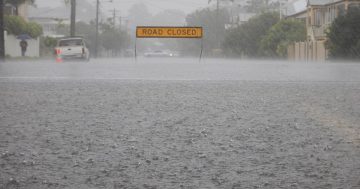
It looks like the Riverina’s moment in the sun will be short-lived with clear skies giving way to rainfall, severe thunderstorms and minor flooding forecast for the days ahead.
Following this week’s declaration of a third La Nina event, the Bureau of Meteorology (BOM) is warning of above-average rainfall over spring and into early summer.
BOM’s engagement officer Morgan Pumpa said things will be wet from Thursday (15 September).
“Due to a high-pressure ridge in the eastern parts of NSW, a cold front associated with a low-pressure system is forecasted to move into the far west today (Wednesday),” Ms Pumpa said.
“It brings in the chance of showers in some parts, including the northern Riverina, later tonight.
“The cold front is expected to continue to move east into tomorrow, which brings the chance of thunderstorms,” Ms Pumpa said.
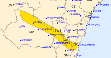
Ms Pumpa warns Griffith and Narrandera may have severe thunderstorms with damaging winds and hail.
On Thursday, Wagga is expected to receive 10 to 15 millimetres of rainfall with a chance of a thunderstorm from the late morning.
Griffith is expected to receive 6 to 10 millimetres of rainfall. The rainfall is expected in the morning and afternoon, with a chance of a thunderstorm from the late morning.
BOM has forecasted that the rainfall will continue until the weekend and early next week.
Ms Pumpa said there was still the chance of showers into the weekend due to a second frontal system from the current low-pressure system.
“There’s a high chance of showers and even thunderstorms for Saturday, and the chances of showers will continue into Sunday.
“For the start of the new week, there is a medium chance of showers being recorded in the gauges.
“It’s most likely that we may see showers in the morning, and the forecast expects less than half a millimetre [of rainfall].
“For the medium chance [of rainfall] we may just see partly cloudy conditions on Monday,” Ms Pumpa said.
On Monday Wagga is expected to have a shower or two with a possible rainfall of 0.4 millimetres during the morning. A high chance of rain is expected for Tuesday with a possible four millimetres of rainfall.
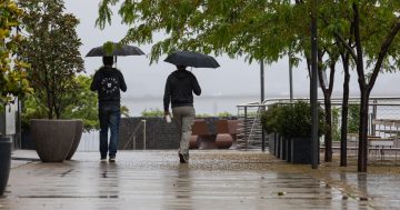
Grab your brollies, we’re in for a wet weekend. Photo: Chris Roe.
Monday is expected to be mostly sunny in Griffith with a 10 per cent chance of rain, but Tuesday is expected to receive up to two millimetres of rainfall.
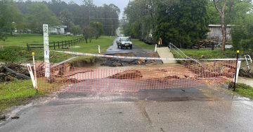
The BOM has also issued a number of minor flood warnings for the region.
A renewed river level rise is occurring along the Murrumbidgee River downstream of Wagga, which has the potential to cause renewed minor flooding at Narrandera and Darlington Point.
Minor flooding may occur along the Murrumbidgee River downstream of Wagga to Narrandera. The river at Narrandera may reach the minor flood level (6.70 m) on Friday.
Minor flooding may occur along the Murrumbidgee River downstream of Narrandera to Darlington Point. The river at Darlington Point may reach the minor flood level (5.50 m) during Thursday. Further rises are possible.
Currently the water levels at the Murrumbidgee River at Wagga (5.25 m) and Darlington Point (5.45 m) are steady and below minor.
However, the water level at Narreandra is rising at 6.44 metres (at 2 pm).
Earlier this month BOM warned the Riverina could be in for a wet spring.
Climatologist Jonathan Pollak explained that the negative Indian Ocean Dipole (IOD) was driving the wet forecast.
He said IOD increased the chance of another La Nina this year due to a wet influence from the Pacific.
He warned going into La Nina would bring wet conditions which would continue after spring and “will be locked in for months at a time”.
BOM recommends that people keep an eye out for the forecast for the latest weather information.
The emergency service asks residents to monitor the latest weather forecasts and warnings and be ready to move to higher ground should flooding develop.
Farmers are advised to move livestock and equipment away from flood-prone paddocks.
For emergency help in floods and storms, call the NSW State Emergency Service on 132 500. In life-threatening situations, call triple zero immediately.
Follow Murrumbidgee NSW SES for updates.